Useful tools and data, developed and curated openly for the community.
mapaPH is a hub for tools built around maps of the Philippines. We build useful open-source utilities using the Philippine map as basis to work with locations, routes, transit, or anything else tied to a place.
Every project is built openly on GitHub. Anyone can look at the code, contribute, or build their own tool on top of what's already here.
We build around the Philippine map to show locations, transit, and data tied to a place.
Fast, simple tools that work well alone or combined with the others.
Anyone can shape what comes next. Contribute, share local knowledge, or build a new tool on top of what's already here.
Note: mapaPH is an independent, community-led open-source index. It is not affiliated with, endorsed by, or representative of the Philippine government or any of its municipal departments. Learn more.
A catalog of open-source applications using maps of the Philippines.
Follow the latest progress, releases, and development milestones across all open-source tools in the mapaPH ecosystem.
Note: Release logs are fetched and updated automatically every 12 hours.
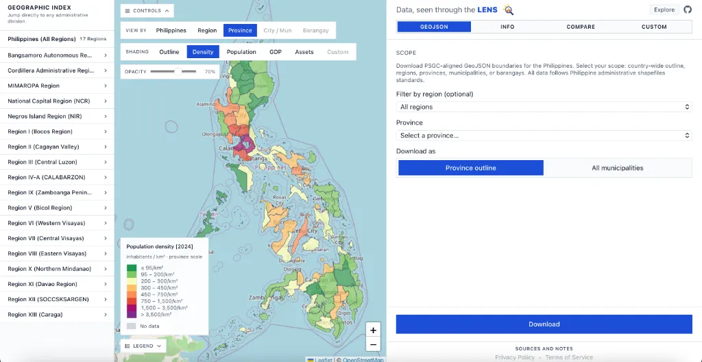
Lens is live with choropleth visualizations for custom data, population density, land area, GDP, assets, and age/sex distribution across region, province, city/municipality, and barangay levels, plus downloadable Philippine GeoJSON boundaries. This marks the start of formal version tracking for the project.
First tracked release of the mapaPH hub.
Everything you need to know about the mapaPH ecosystem, data sources, and tools.
mapaPH serves as an open-source hub and technical documentation index for web applications built around maps of the Philippines. Our primary mission is to liberate siloed Philippine spatial data—including census demographics from the PSA, municipal financial audits from COA, and transit networks—making them accessible via interactive, browser-native tools without requiring expensive GIS desktop software.
Yes! All source code repositories, dataset compilation scripts, and GeoJSON boundary files hosted across the mapaPH organization are open-source and licensed under the permissive MIT License. You are free to inspect, fork, modify, and integrate our spatial files into both non-commercial research projects and commercial software applications without royalty fees.
Every tool in the mapaPH suite is developed publicly on GitHub. Anyone can participate by opening issue tickets for bug reports, proposing new mapping tools, submitting pull requests for code enhancements, or helping curate crowdsourced dataset listings. You can find direct GitHub repository links under each application's documentation page.
For directory-based utilities and transit route community submissions, data updates are submitted as pull requests against public JSON/YAML data files. Maintainers verify spatial coordinate sanity, check entries against official place registries (like the PSA PSGC catalog), and run automated validation tests before merging changes into production builds.
All government datasets displayed in our visualizers (such as census demographics, electoral results, and local government financial reports) are acquired from public official releases published by the PSA, COMELEC, and COA under the Philippine Freedom of Information (FOI) framework (Executive Order No. 2, s. 2016). We do not store or process personal identifiable information (PII).
The mapaPH hub website is built as a static site generated via Astro and does not use tracking cookies or intrusive third-party user fingerprinting scripts. While third-party advertising partners (like Google AdSense) may set standard advertising cookies to display relevant ads, our core open-source web applications prioritize zero telemetry and user privacy protection.